Hiking Elvas: Trails Ranked by Difficulty and Scenery
Five hiking routes out of Elvas, ranked from a dawn walk along the bastion walls to an 18 km push to the Caia border. Where to sleep, what to eat, and why November is the best month to harvest olives with the locals.
Elvas isn't where most people lace up their hiking boots. Visitors come for the walls, for the famous candied plums, for that obligatory photograph of the Amoreira Aqueduct slicing the sky like an opera set. Then they have lunch, take a nap, drive home. Mistake. The same geography that turned this town into a 17th-century military miracle, the low hills, the plains rolling unchecked toward Spain, the stubborn olive groves, is exactly the geography that makes the surrounding countryside one of the Alentejo's most underrated places to walk.
The trick is not to expect the Serra da Estrela. There's no vertigo here, no dense pine forest, no perfectly signposted route. What you get instead: relentless sun from May to September, very little shade, paths of schist and gravel that destroy cheap soles. You also get real silence, the kind that has almost vanished from Portugal, and at sunset, horizons where you can swear you see the curve of the earth. It's worth it. But you need a plan.
Before you lace up: what no one tells you
First: don't even think about hiking between June and mid-September unless you're out the door by six in the morning and back by ten. Alentejo summers are not a literary device, they're a public health hazard. Pack two litres of water per person, even on a short loop, even when it feels excessive. It isn't.
Second: footwear. Running shoes won't cut it on most of these routes. The loose stones around the Forte da Graça and Santa Luzia are tiny ankle traps in disguise. Mid-cut hiking boots, or at minimum decent trail runners.
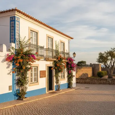
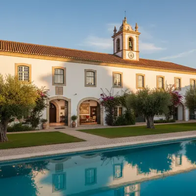
Third: for a sensible base, there are two honest options in Elvas. The Vila Galé Collection Elvas occupies the former Convent of São Paulo inside the walls, with a pool for the sweaty homecoming and a serious breakfast. For something more intimate and at a more grounded price, the Alojamento Escola do Fado in Vila Fernando, fifteen minutes by car, is what I'd recommend to a friend, especially if the plan is to mix hiking with long evenings and wine.
Trail 1 (Easy): The walls, walked at dawn
Distance: roughly 4 km. Elevation: negligible. Duration: 90 unhurried minutes.
Start at the Praça da República and skirt the bastioned belt from the outside whenever possible. It isn't an official trail, it's part goat path part minor road, but it works. Leave at seven in the morning. Seriously. Sunlight hitting the curtain walls, swallows in spirals over the bastions, the smell of fresh bread from one of the bakeries on Rua de Olivença: it's one of the best sensory moments the Alto Alentejo offers, and it's free.
Anyone who has done urban walks in walled towns knows the appeal. For a similar approach in another Alentejo city, our Portalegre on foot guide applies the same logic: walk slowly where tourists only drive by.
Real difficulty: 2/10. Scenery: 7/10, especially with cooperative skies.
Trail 2 (Easy-Moderate): Amoreira Aqueduct to the olive groves
Distance: 6 to 7 km return. Elevation: gentle. Duration: about 2 hours.
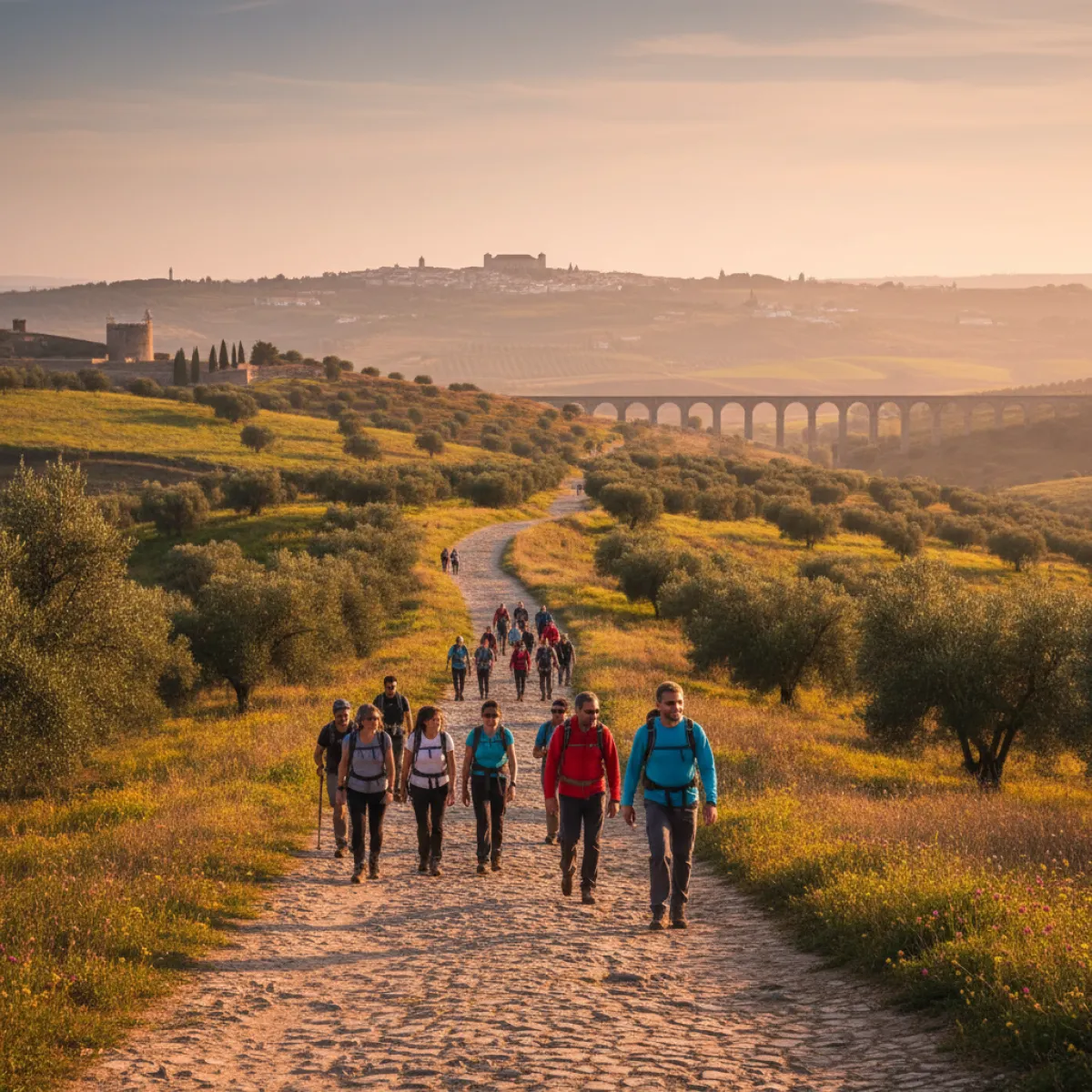
Pick up the aqueduct at the section where the arches reach maximum height and follow it out of the city to the north. There's a dirt path that hugs the structure for almost its full useful length. The Amoreira aqueduct, remember, took roughly a century to build and remains one of the largest civilian hydraulic works in the Iberian Peninsula. Walking under it, watching the arches drop in height as the terrain rises, is an engineering lesson with no textbook.
Here's what guidebooks won't tell you: bring a bag. In October and November, the olive groves along the route are heavy with fruit, and if you're lucky and friendly, you may meet producers selling new oil straight from the press in reused bottles, at prices that are laughable compared to Lisbon. Check times locally, this isn't Disneyland, it's real life with sacred lunch hours.
Difficulty: 4/10. Scenery: 8/10. Best month: November, during harvest.
Trail 3 (Moderate): Forte da Graça and the Conceição hill
Distance: about 8 km loop. Elevation: 200 m cumulative. Duration: 3 hours.
This is the trail that justifies the proper boots. Leave the city through the Porta do Cano, drop down to the plain that separates Elvas from the Forte da Graça (also known as Forte de Nossa Senhora da Graça, or Forte do Conde de Lippe), cross that flat ground, and climb the hill where the fort plants itself like a stone ship. It takes time. The final climb is fully exposed to the sun and never quite ends when it seems about to.
The fort was designed to be unassailable and, up close, you understand why. It was a high point of modern fortification in Portugal and part of the city's UNESCO listing. Paid entry is worth it, especially for the rooftop views, but confirm hours on the day, because they shift by season.
The return can be made via a westward loop, passing the remains of the Forte de Santa Luzia, the smaller but equally stubborn sibling, a perfect star on the ground. Anyone who enjoys this kind of circuit should also read our Portalegre weekend guide without the tourist traps, which follows the same philosophy: combine a base city with on-foot escapes.
Difficulty: 6/10. Scenery: 9/10. Warning: zero shade between the city and the fort. Don't try this in August.
Trail 4 (Moderate-Hard): Vila Fernando hills loop
Distance: 12 km loop. Elevation: 250 m. Duration: 4 hours.
This is my favourite, and it isn't an accident that I recommend sleeping in Vila Fernando if you want to do it properly. The village sits east of Elvas, still within the municipality, surrounded by old rural paths that once connected farms, fountains, and roadside shrines. Few people walk here. You'll meet more sheep than humans.
The classic route starts at the Vila Fernando church, climbs through the upper village, leaves via the Fontainhas track, skirts two estates whose olive hedges look like they were drawn by someone with mild OCD, and returns through a valley where, in spring, the carpet of poppies and daisies is the kind of photograph nobody believes.
The bonus of this option is what waits for you at the end of the day. Vila Fernando has a fado tradition that's barely known outside Alentejo, and anyone staying at the Alojamento Escola do Fado is metres from where they hold a night of fado and tradition at the old school of Vila Fernando. Hike 12 km in the morning, take a long nap, fado in the evening, dinner of charcuterie boards: that's the perfect sequence.
Difficulty: 7/10. Scenery: 9/10.
Trail 5 (Hard): The Caia banks toward the border
Distance: 18 km return. Elevation: little, but the sun and distance are unforgiving. Duration: 5 to 6 hours.
For anyone wanting a serious challenge, dropping down to the Caia river and following its course toward the Spanish border is the most ambitious trail I'd recommend out of Elvas. It isn't technically hard. It's psychologically long. The Caia is a shallow river with pools where locals swim in summer, and the landscape alternates between poplars, cork oaks, and a thousand shades of brown-yellow depending on season.
Bring food. There are no cafes. There's nothing. There's a silence that becomes physical after two hours, and that's the point. Bring a mental vaccine against boredom too: this trail doesn't impress with spectacular views, it impresses with persistence. It's a pilgrim's trail, not a tourist's.
Difficulty: 8/10. Scenery: 7/10 (extra points if you like monotonous landscapes in the best sense of the word).
Where to eat afterwards (and what to avoid)
The mistake hikers make in Elvas is falling for the square restaurants with laminated four-language tourist menus. Run. The rule I apply across Alentejo is simple: eat where the cars at the door have older Portuguese plates and the TV is on whatever channel at lunchtime volume. For a deeper analysis of the same philosophy in another Alto Alentejo capital, read our guide to where locals actually eat in Portalegre.
In Elvas, order migas with pork, ensopado de borrego, and if the place has it, black pork cheeks. For dessert, ameixa d'Elvas, but ideally outside high tourist season (you tend to get fresher batches the rest of the year). Regional wines: ask for clay-pot tinto de talha if available, and if the waiter gives you that look that says he gets you, even better.
And at night, when the legs are wrecked
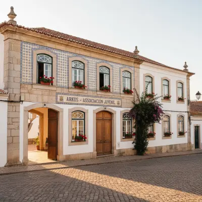
Some people think life in Elvas ends at eight. It doesn't, but it requires local knowledge. If you're sleeping inside the walls you can finish the night on any terrace of the Praça da República with a slow drink, but the best cultural surprise in town is, against expectation, a youth association. Arkus, Associação Juvenil runs an irregular but consistently interesting programme, mixing fado, theatre, and community initiatives. Check the calendar before going, but if you happen to land on a programmed evening, it's the best thing you'll do in Elvas outside the lit-up walls.
Verdict: is hiking enough reason to come?
Yes, with an asterisk. Elvas isn't Gerês, isn't Arrábida, isn't what people immediately picture when they think hiking in Portugal. It's a different beast. It's the kind of trail where you walk slower, meet no one, and the landscape doesn't shout but works on you for weeks after you get home. Combine two or three of these routes with well-fed evenings, real wine, and a fado night that nobody in Lisbon knows exists, and you have a weekend that justifies the 200 km from the capital.
Then don't tell anyone. Let it stay this way, please.