Tavira's Hiking Trails Ranked: Flat to Fierce
From salt pans where flamingos feed at dawn to the Serra do Caldeirão where schist replaces sand, Tavira hides trails for every level. We ranked them by difficulty and scenery so you know exactly what to expect.
Most visitors think of Tavira as a town for strolling, Roman bridge, cobblestones, a port wine by the Gilão River. Nothing wrong with that. But the municipality of Tavira hides some of the Algarve's most varied walking terrain, from dead-flat salt pan paths where flamingos feed at dawn to mountain circuits through schist villages where GPS becomes non-negotiable.
I've walked these trails across different seasons. What follows is an honest ranking, by difficulty and scenery, so you know exactly what you're signing up for before lacing your boots.
1. Tavira Salt Pans, Flat, Easy, Spectacular
Distance: Variable (2–6 km round trip) · Difficulty: ★☆☆☆☆ · Scenery: ★★★★☆
If you want a walk where the biggest challenge is not stepping in a puddle of brine, start here. The salt pans stretch between Tavira and Cabanas, and the easiest access is along the road connecting the two, several dirt tracks branch off into the pans from various points.
Go early. At seven in the morning, low-angle light turns the evaporation pools pink, and flamingos are feeding in the shallows. Avocets, stilts, and egrets work the channels with the indifference of creatures long accustomed to humans. It's flat, it's easy, and the only gear you need is decent binoculars and shoes you don't mind getting dirty.
No ticket, no schedule. Bring water, there's no shade and no fountains. If you want to pair the walk with something, the wine experience at Al-Lagar is a few kilometres away and makes a smart way to finish the morning.
2. Pedras d'el Rei → Praia do Barril, The Classic with a Payoff
Distance: ~3 km (round trip) · Difficulty: ★☆☆☆☆ · Scenery: ★★★★★
Everyone does this one, and they should. From the car park at Pedras d'el Rei, you cross the Ria Formosa on a pedestrian bridge and boardwalk for 1.3 km to Praia do Barril, on Tavira Island. There's a miniature train that covers the same distance, but walking is incomparably better: the path crosses salt marsh, tidal channels, and dunes, with birds everywhere.
The arrival is cinematic. Hundreds of rusted anchors standing in the sand, the Anchor Cemetery, mark the site of the region's last tuna fishing camp. These weren't boat anchors: they held the massive armação nets to the seabed. It's one of the most photogenic spots in the Algarve and, outside July and August, you'll practically have it to yourself.
From Barril, you can continue east along the beach toward Praia da Ilha de Tavira, another 2–3 km of sand with the ocean on one side and the lagoon on the other. If you start from Santa Luzia instead of Pedras d'el Rei, the full round trip comes to about 10 km.
Practical tip: There are restaurants at Praia do Barril (open in beach season), but off-season you'll want to bring a snack. Parking at Pedras d'el Rei is free but fills up fast on summer weekends.
3. Pego do Inferno, Short, Beautiful, Underrated
Distance: ~1 km (round trip) · Difficulty: ★★☆☆☆ · Scenery: ★★★★☆
Seven and a half kilometres inland from central Tavira, a bend in the Ribeiro do Almargem conceals a roughly 3-metre waterfall dropping into an olive-green pool about 7 metres deep. It's not Niagara, but nobody expects to find this in the dry Algarve, and that contrast is what makes it.
The trail itself is short: 400–500 metres from the car park, descending on wooden stairs and a dirt path through Mediterranean woodland, carob trees, cork oaks, strawberry trees. The descent is gentle but can be slippery when wet, so wear shoes with grip.
Go in spring or early autumn. In summer, the waterfall may slow to a trickle. Entry is free. There are no facilities, no toilets, no café, nothing. It's a place to go, look, and come back.
If you're based in Tavira and want a quick taste of the interior without a major commitment, this is perfect. Combine it with lunch in Santo Estêvão, the nearest village, where small local restaurants serve honest food at local prices.
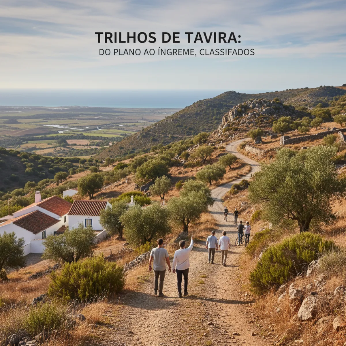
4. Masmorra Trail (PR8), The Serra Gets Real
Distance: 5.5 km (circular) · Difficulty: ★★★☆☆ · Scenery: ★★★★★
This is where things change. The PR8 is a circular trail based in the village of Mealha, in the Cachopo parish, deep in Tavira's hinterland, where the Serra do Caldeirão begins to assert itself. We're talking schist country: whitewashed houses, cattle pens, ancient circular stone buildings that look like they belong to another century.
The walk takes about 2 hours and the difficulty is moderate, there's elevation change, but nothing requiring special fitness. The real problem is signage: it's poor. The trail starts by a former primary school in Mealha, but the markers aren't always clear. Bring GPS or download the track before you go. I mean it.
To get there, drive from Tavira toward Cachopo, then toward Martinlongo, the turn to Mealha is signposted from the road. You need a car. There's no public transport, no restaurants in the village, nothing but quiet and landscape.
Best season: Spring (everything in bloom) or autumn (mild temperatures, golden light). Avoid summer, there's no shade and temperatures in the serra can top 35°C.
If you want to understand the contrast between coastal and interior Algarve, this trail is essential. It feels like a different country from the beaches. For a broader sense of what the real Algarve looks like beyond the coast, our guide to local culture in Faro covers traditions you'll still find in these mountain villages.
5. Via Algarviana, Tavira Stage, For Serious Walkers
Distance: ~25 km (linear) · Difficulty: ★★★★★ · Scenery: ★★★★★
The Via Algarviana (GR13) is the grand route connecting Alcoutim to Cabo de São Vicente across 300 km of Algarve interior. The stage passing through Tavira's municipality, from Vaqueiros to the city, roughly 25 km with 670 metres of cumulative elevation gain, is among the toughest and, simultaneously, the most beautiful.
It crosses the Serra do Caldeirão, passes through villages where time seems stuck, descends through valleys of cork and carob trees, and finishes beside the Gilão River with Tavira's rooftops finally in view. Expect 6–7 hours of continuous walking with no shortcuts. This is not a stroll, it's a proper hike, for people who know what they're doing.
The route is well-signposted (unlike the PR8), but always carry GPS, enough water for a full day (minimum 2 litres, more in warm weather), food, sun protection, and a charged phone. There are virtually no resupply points along most of the route.
Logistics: Being linear, you'll need to sort transport. The most practical option is to leave your car in Tavira and arrange a ride to the start point, or use a taxi. Check locally, there's no regular transport service to the start of the stage.
After a day like this, what you want is a comfortable place to recover. Fazenda Nova Country House sits just outside Tavira and is exactly the kind of retreat that makes sense after kilometres of mountain terrain: rural setting, pool, quiet. Check prices and availability directly with them.
Practical Notes for All Trails
When to go
March to May and September to November. Full stop. The Algarve summer is brutal for hiking, 38°C with no shade isn't uncomfortable, it's dangerous. Winter can be pleasant on sunny days, but rain makes some dirt trails impassable.
What to bring
- Water, more than you think you need
- Sun protection and a hat (even in spring)
- Hiking shoes with decent grip (essential for the serra; trainers are fine for the salt pans)
- GPS or app with downloaded tracks (Wikiloc and Komoot have Tavira's trails well mapped)
- Snacks, outside the beaches, there are no food points on any of the trails
Getting there
Tavira is 30 minutes from Faro. A car is virtually essential for the trails outside town, Pego do Inferno, Masmorra, and the Via Algarviana aren't accessible by public transport. For the coastal walks (salt pans and Praia do Barril), you can cycle or even walk from the centre.
Exploring more of the Algarve
If Tavira has whetted your appetite for the rest of the region, our Lagos neighbourhood guide is a good starting point for the western Algarve. And for understanding the traditions that still shape these lands, there's our guide to local culture in Albufeira, which shows there's life beyond the strip.
The Verdict
Tavira isn't just a pretty town with beaches, it's a territory of contrasts that reveal themselves to those who walk. From sea-level salt pans to the serra at 500 metres, there are trails for every level. But my favourite? The PR8 Masmorra Trail. It's not the longest, it's not the hardest, but it's the one that surprises most. Standing in the middle of the Serra do Caldeirão, surrounded by schist and silence, 40 minutes by car from the beaches, that's the Algarve most people never see.